2001 Mars Odyssey
previous Mars Surveyor 2001 Orbiter
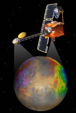 2001 Mars Odyssey,
named after Arthur C. Clark's novel, '2001: A Space Odyssey,'
and previously called Mars Surveyor 2001 orbiter, was successfully
launched on
April 7, 2001
from Cape Canaveral with a Delta II rocket. After an
interplanetary
cruise of more than 6 months, the spacecraft reached planet Mars and was
successfully
inserted into Mars orbit on October 24, 2001, 2:55 UT (October 23, 7:55 pm
Pacific).
Aerobraking phase followed from October 26, 2001 to January 11, 2002.
2001 Mars Odyssey,
named after Arthur C. Clark's novel, '2001: A Space Odyssey,'
and previously called Mars Surveyor 2001 orbiter, was successfully
launched on
April 7, 2001
from Cape Canaveral with a Delta II rocket. After an
interplanetary
cruise of more than 6 months, the spacecraft reached planet Mars and was
successfully
inserted into Mars orbit on October 24, 2001, 2:55 UT (October 23, 7:55 pm
Pacific).
Aerobraking phase followed from October 26, 2001 to January 11, 2002.
During the aerobraking phase, the highly-excentric initial Mars orbit into which
Odyssey was originally inserted (to save fuel) was lowered by using the friction
of Mars' atmosphere; this orbit has a farthest point of 27,000 kilometers above
Mars and a closest approach of 128 km (nearly 80 miles) above Mars' surface. At
the end of this phase in January 2002, the lowest point (periapsis) was still at
about 120 km or 75 miles above the planet, and the most distant point (apoapsis)
be lowered to near 500 km or 311 miles.
Then, onboard thrusters were fired to raise the periapsis and achieve a nearly
circular 400 km Polar orbit, a maneuver called periapsis lift.
The
first maneuver to raise the periapsis was successfully completed on January
11, 2002 and ended the aerobraking phase.
It was followed by two orbit-tuning firings on January 15 and 17, and
two final fine-tuning maneuvers on January 28 and 30, 2002.
Now in its
mapping orbit, the 2001 Mars Odyssey spacecraft has
started to conduct science from orbit, its primary science mission
covering the time of February, 2002 through July, 2004 (917 Earth days).
This Mars orbiter mission is to perform the research originally scheduled for
the lost
Mars Climate Orbiter (Mars Surveyor 1998 Orbiter),
i.e., Mars weather and climate. Scientific investigations include
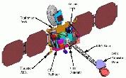
mineralogical mapping and radiation measurements, with its main instruments
GRS (Gamma
Ray Spectrometer) from Mars Observer,
THEMIS
(Thermal Emission Imaging System) which is developed under the direction of
ASU, and
MARIE
(Mars Radiation Environment Experiment).
Early findings include
enormous quantities of water ice under Mars' surface, announced
May 28, 2002, confirming
optimistic theories of Mars scientists, and
clues about Rock Layer History for thermal maps.
Mars Odyssey's THEMIS
has begun to post daily images.
The spacecraft may also serve as communications relay for future Mars landers
such as the 2003 Mars Exploration Rovers.
Latest Mars Odyssey 2001
THEMIS Mapping Mission Images of the Day
2001 Mars Odyssey - Image Gallery (JPL)

2001 Mars Odyssey Logo;
2001 Mars Odyssey Spacecraft;
Older Mars Surveyor Orbiter 2001 Concept
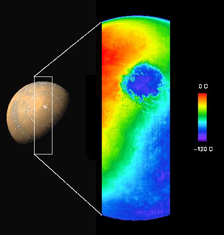
Odyssey's First Image of Mars -
thermal IR image from above south pole. Taken October 30, 2001 from a height
of 22,000 km (13,600 miles) above the planet.
JPL Photo Caption PIA-03459, October 31, 2001
JPL Photojournal Caption
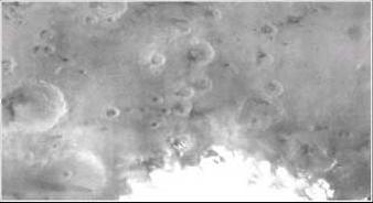
Odyssey's first visual image of Mars -
click to see the location of this image within an IR image like that above.
Both images were taken on November 2, 2001 from a height of about 13,600 miles
(22,000 km). The late spring south polar cap is about 540 miles (900 km) in
diameter at this time.
JPL Photo Caption PIA-03461, November 13, 2001
JPL Photojournal Caption
![[Mars Surveyor 2001 Logo]](Pics/2001logo.jpg)
Hartmut Frommert
[contact]
![[Mars] |](../Jco/mars.ico.jpg)
![[Spider] @](../Jco/spider.ico.jpg)
![[SEDS]](../Jco/seds.jpg)
Last Modification: November 21, 2001
